In just a few weeks, the world as we know it has changed, as the Covid-19 pandemic has made major changes to our daily lives, our basic needs, businesses and methods of transportation.
The requirements for social separation, curfews, total or partial closures, and many other restrictions on freedoms were enforced for health reasons due to the spread of the virus; all of these reasons motivated us as urban planners to stand up and evaluate the components of our urban environments, and the implications for our communities’ psychological and physical health.
In a serious attempt to improve reality, we want to create a better normal, so that we can move safely in the circle of our daily lives without returning to the unfair and unsustainable patterns of the past. We need to shape a better future through our public urban spaces to meet our needs and raise the level of our lives.
"Through my personal experience during the quarantine period, when it was difficult to navigate obtaining basic home requirements in the area where I live, I was prompted to think about this research paper to improve our reality."
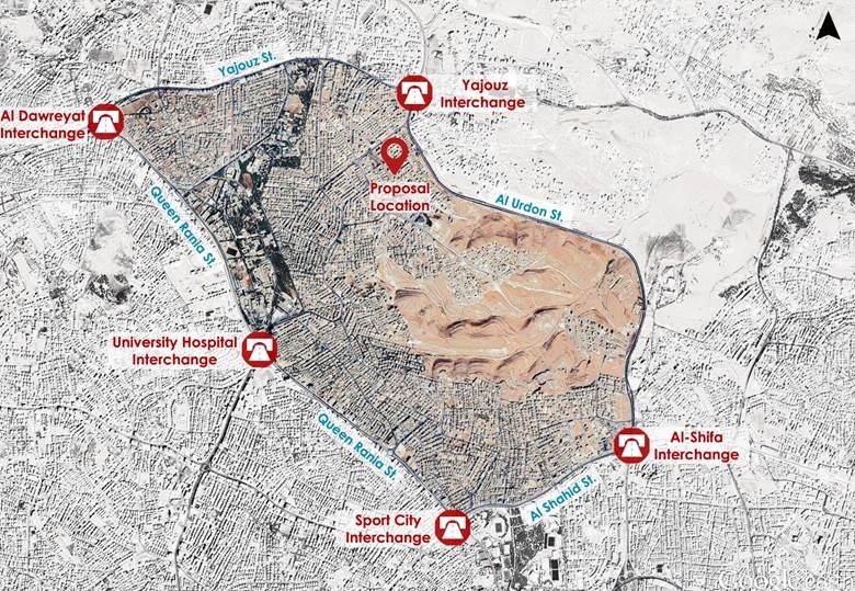
After studying the current situation in the area where he lives in Amman, which is the neighborhood of The Islamic Scientific College neighborhood, Jubeiha, Architect and Urban Planner Firas Sweidan compared it with international standards in urban planning and design. He clarified the general concept of urban planning and reviewed the general planning standards provided in the residential areas with general hierarchical classifications starting from the residential cluster level up to the city level.
Where the public services, walkability and accessibility standards are linked to the reduction of friction and mixing between different housing groups, this contributes to the easier identification and isolation of zones.
The principles of city hierarchy planning are based on:
The city hierarchy: Building > Cluster > Neighborhood > Residential District > Residential Area > Residential Sector > City.
Served population and population density.
Safe walking distance for local residents, which mainly depends on the topography of the area and the climatic condition of the study area.
Providing public services at all levels of planning that are appropriate to the needs of the local population.
The road network serving the area.
The pedestrian networks of all kinds.
Urban connectivity in design.
Societal identity.
Improving the economic environment.
Sustainability
The provision of accessible public services and the provision of a pedestrian network within a safe walking distance according to the correct design criteria are directly related to the epidemic restriction during the spread period. The local population should be able to secure their basic needs within the residential cluster and without the need to mix with other neighboring clusters, thus creating confined areas within the scope of one residential cluster.
After studying the population area within his cluster, which is a general living situation that is widespread in Jordan, and within a safe walking distance of the catchment radius of approximately 300m, Firas documented:
The public services located within the cluster that he lives in.
A study of the street width ratio and cross-sections.
The pedestrian network that the cluster lacks.
Wrong practices of the population and organizational aspects.
.png)
Firas then formulated his vision and solutions to improve the current reality in a way that will positively affect the life and welfare of the population. His proposal includes the following suggestions:
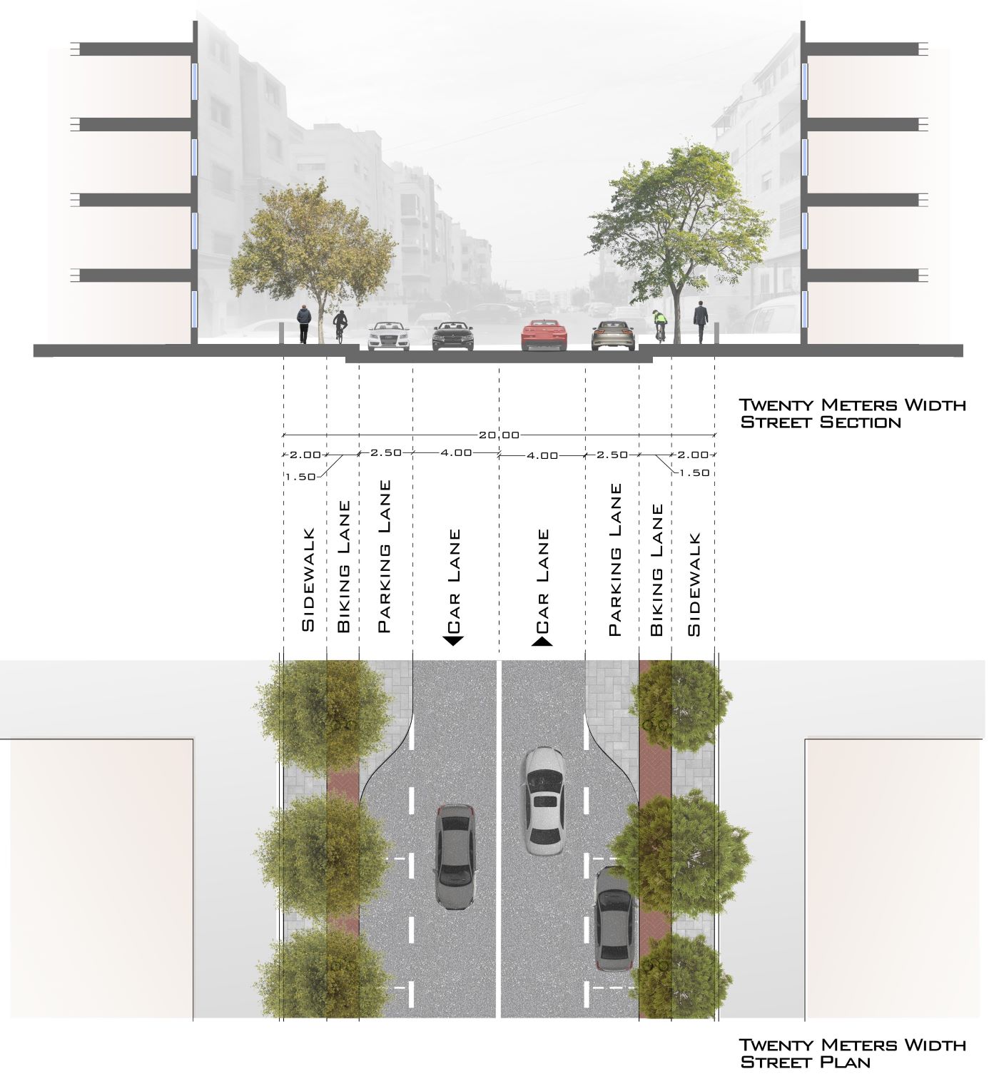
1. Implement one-way traffic in some areas to allow changes to sections of the streets in order to meet design standards, and residents' needs.
Study the local road network, including streets of 12m, 14m, 16m, and 24m in width as well as walking directions and street sections. Changing the direction of traffic to become one-way reduces car exhaust gas emissions and enhances traffic flow, positively impacting the local environment and the general health of the population.
The changes to the roads should include the following:
- Increase the width of the sidewalks from 90cm to 200cm.
- Use suitable vegetation that allows space to walk underneath without blocking the pedestrian sidewalks.
- Provide bike lanes within the road section.
- Provide one lane for parking on the street instead of two lanes, and activate the role of GAM in providing parking inside the residential buildings.
- Determine and standardize paving walkways.
- Determine and standardize the sidewalks.
2. Provide basic services that each residential cluster needs.
Residential clusters must contain a public park of an appropriate size for the population and adequate grocery services, vegetables, pharmacy etc. as well as a kindergarten, a local health clinic and a local mosque.
3. Allow the construction ratio to change so that the balcony is not counted among it.
Also allow the emergence of home balconies between 1-1.5m within the front setback that can be devoted to planting the balcony borders. This is important for its positive psychological and health impact on the apartment’s residents, whose housing lacks other outdoor spaces.
4. Provide green gardens on the roofs of residential buildings.
Roof gardens will serve the residents of each building and can become an outlet for them that reflects on their psychological and health comfort. They also work to hide water tanks on the roof.
5. Allocate residential buildings' roof spaces to public services.
Instead of illegally selling the roof spaces of residential buildings to the last floor apartments within the buildings and using the space as an affiliate apartment, Firas urges his proposal to provide greenhouses that can be planted with basic crops such as fruits and vegetables for residents’ use.
The benefits of this include:
- The creation of a physical agricultural activity for the population that has a positive psychological impact.
- Providing residents with a part of their basic food products.
- Providing a work team to coordinate with the Ministry of Agriculture to sort farms for each region that intends to plant crops, and sell the surplus locally while generating income to spend on improving the region.
- Creating space for water harvesting on the roof's surface so that the collected water is used to irrigate the trees planted on the side-walks and crops in the greenhouses on the roof.

Firas also reviewed a number of the projects he has worked on in CCG. In his presentation ‘Back to a Better Normal’ he explained how to observe the general planning standards and reflect them in the projects designed, according to their different nature and locations.
He also discussed the higher level of city planning, which deals with regional planning and its importance in achieving a balance within the country. This level of planning studies and analyzes the different regions within the state, enhances the comparative advantages of each of them, and links them to achieve economic integration of the state.
![]()
![]()
![]()
Firas Sweidan is an experienced Architect, Urban Planner and Designer who has worked with various multinational and multi-disciplinary firms in both consultancy and contracting. He has worked on a wide variety of project types and scales, and has over 15 years of experience in the industry, including 7 years with CCG. He is an advocate for excelling human societies through Urban Planning as a process of solving problems in a creative manner.
CCG’s urban and regional planning team works on a wide range of planning projects from city centers to suburban segments and new developments to urban regeneration and conservation. Our planners conduct studies and embrace a multidisciplinary approach to create and implement urban plans that are sustainable and efficient. Our planners understand the integral role that development plans play in the welfare of communities and always aim to optimize use of land and ensure a solid basis for natural and socioeconomic systems.
If you would like further information about the services our urban planning team provides, or if you would like to speak with one of our specialists, please contact us on +962 6 461 2377 or email bd@group-cc.com.